Wednesday, October 3, 2012

Final Blog Post for "The Trip"

Mike and Judy Here 
pics by Mike

It was in a Jack-in-the-Box restaurant in Winnemucca, Nevada that the decision was made  ----  We are going home. 

After 45 days of motels and with Mike, Mary ,and Judy sick, we didn’t feel we could enjoy the great things there are to see in Utah and Colorado.  So we headed east across I-80. What a long, lonely, boring drive, dodging trucks all the way. 

We arrived in Benton Harbor, Michigan on Oct. 1 and had a final dinner together.

Jim, Mary, Judy, Mike 
We're still talking to each other and we're still friends. It was sad to part ways with Jim and Mary.  Such good friends, such a great trip, such a wonderful experience! We arrived home on the 2nd and saw a beautiful view!

 Sage Lake - Our Home
 Home sweet, home. Hope you all enjoyed following us on the blog.

Thursday, September 27, 2012

Day 38 - (9-27-12) - Redwood Forest and Crater Lake

Maryann Here
pics by maryann

As Mike said tonight, 'it seems like we've all gone downhill since the cruise.'  Three of us are still not feeling up to par.  We have congested coughs and from coughing so much our rib cages hurts.  Really all we feel like doing is laying down and sleeping.  We do pretty well until about noon and then we start to decline.  Hopefully by tomorrow we will all feel a bit better. 
Jim and I went to the Redwood Forests yesterday but to be honest it's incredibly hard to photograph a tree that is 304 feet tall, 21.6 feet in diameter, 68 feet around and 1500 years old, so I didn't.  This tree is known as "The Big Tree" and to be standing next to it makes you seem so small.
Jim standing in front of "The Big Tree"
Yesterday after we came back from that we just took the day off.  Mike and Judy were laying low as he was really not feeling well at all.
Today we took off for Crater Lake and to me it seemed like we would never get there.  But we did and it was worth it as it was gorgeous.  I found it hard to believe that the depth of the water was 1900 feet deep.  The color is an amazing blue color and today there were tons of reflections.  Actually they sort of took away from the deep blue that I've read so much about.  What a beautiful spot to visit.

This lake was formed from The Mazama volcano

The famous Wizard Island

Hard to believe but it's a thousand feet down to the water

Jim and I resting

The water was such a deep blue.
We had lunch there (terribly expensive) spent around an hour walking around and decided to leave.  So here we are in Lakeview, Oregon for the night. 
Funny thing happened as the four of us pulled up at this Jerry's Restaurant for dinner, we noticed this trike pull up next to us.  As we got out of the car I looked over and said, "Hey I know you."  We had breakfast with them at the motel by Mt. St. Helens a few days ago.  So we invited them to join us for dinner.
Tomorrow we are driving all day heading toward Utah and Bryce.  We will make it about half the way there as it's around 800 miles. 


Information on Crater Lake

maximum depth (July 2000) 1,949 ft

maximum depth (Year 1959) 1,932 ft

minimum depth (near Phantom Ship) 15-25 ft

average depth 1,148 ft

max diameter of caldera at the rim (east-west) 6.02 mi (east-west)

min diameter of caldera at the rim (north-south) 4.54 mi (north-south)

surface area 13,069 acres

highest peak in the park (Mount Scott) 8,929 ft

highest peak on the rim (Hillman Peak) 8,151 ft

average height of the caldera rim
7,178 ft above sea level

(1,000 ft above lake surface)

record clarity depth (August 1994) 134 ft

average clarity depth 90-100 ft
Crater Lake is filled with rain and melted snow that fell within the caldera basin. Crater Lake is isolated from surrounding streams and rivers, thus there is no inlet or outlet to the lake. Its primary input is from annual precipitation in the region. Average annual precipitation is (66 in); average annual snowfall is (44 ft). It took approximately 250 years for the lake to fill to today's level 6,178 ft above sea level. The lake maintains its current level because the amount of rain and snowfall equals the evaporation and seepage rate. Lake level has varied only over a range of (16 ft) in the past 100 years.
Crater Lake is known to be the deepest lake in the United States and the seventh deepest in the world. A maximum lake depth of (1,996 ft) was recorded by a group of USGS representatives in 1886 using piano wire and lead weight. The maximum depth of (1,932 ft) was established in 1959 by the USGS using sonar measurement. This depth is referenced at the surface elevation of (6,176 ft). But since its primary input source is dependent upon the climate, lake level is subject to abrupt changes. Crater Lake partially fills the collapsed caldera of the ancient Mount Mazama Volcano. The caldera is a bowl-shape depression of about (4,000 ft) deep.
The record clarity of Crater Lake was measured at a depth of 41 m (134 ft) in August 1994. The lake clarity is measured with a secchi disk, a black and white disk lowered into the water with a cable. Its exceptional clarity is mainly due to its isolation from streams and rivers. There is no incoming stream to bring any organic materials, sediments, or chemicals to pollute the lake, although natural plankton in the lake and wind-borne pollen have seasonal effects on water clarity. Particulate materials and chemicals are mainly introduced into the lake through precipitation and run-off of the calderal walls. The caldera wall is composed of volcanic rocks that do not react with or dissolve easily in cold water, although warm water escaping from the caldera floor adds a small amount of dissolved solids.


Wednesday, September 26, 2012

Day 36 - (9-25-12) From Newport,OR to Crescent City, CA

Newport to Crescent City

MaryAnn Here
pics by maryann

Once again we left with a hazy fog in the air as we headed south.  It was almost a repeat of yesterday but with lots more stops.  The Pacific coast is just beautiful but in a wild rugged way.  I could not get over how the waves came crashing into the shore.  The waves came with such force they would just hurdle over making the loudest sounds.  I don't think I would ever want to be in the middle of one of those waves.  I know these pics do not show it but those waves were really noisy coming in.


Some of the areas were calm and inviting
Just south of North Bend, OR we did get the chance to see a lot of seals/sea lions. (??) I mean a lot of them.  When we stopped the car we could hear them before we even opened the door.
The brown color in front of the huge rock is all seals or sea lions.
They were all piled on the rock.
Double click on the pic to see them better.  There are I think two different kinds of seals or they might even have been sea lions, don't know.

We stopped for lunch at one of the golfing capitols of the world, Bandon.  It wasn't long after that when all hell broke loose.  
Three days ago I was sick with what I will call a sinus infection but I was starting to feel better.  Mike this morning said his throat was on fire so in their car Mike was shivering and sleeping most of the day.  Judy said he even had the heat turned on.  I totally understood how he felt.  So all of a sudden it hit me.  I'm calling it food poisoning!  I yell for Jim to pull over along side the road and there I am barfing in the bushes while Mike is still shivering but is no longer sleeping in their car.  Judy and Jim I know are thinking 'get me out of here.'  Isn't long before I'm asking Jim to find a bathroom because the eruption of Mt. St.Helens would be nothing compared to how I felt.  I have to tell you I almost shut southern Oregon down single handed.  If I wasn't having Jim stop at a bathroom I was barfing in a bag.  It was just ugly.  I mean ugly. 
The good news is I feel fine now but wonder if I will ever eat eggs or bacon again.  Mike is feeling a bit better tonight too.
Fortunately the car was saved and we are not going to have to sell it.
Gorgeous Area
Calm spot
Lighthouse way in the distance
As you may have guessed Mike and I did not really do justice to the southern part of the Oregon coast as in my case Jim's total focus was on finding the next bathroom so he could not look much either.  Judy was just smothering from the heat in the car with Mike shivering so she did not see much either.
So we have decided to stay put in Crescent City for the day so Mike can rest up and hopefully will feel well enough to travel tomorrow.  He'll be on meds by then so should be fine.

Tuesday, September 25, 2012

Day 35 - (9-24-12) - Oregon Coast

Oregon Coast to Newport

Maryann Here
pics by maryann

We left Washington behind as we crossed over to Oregon and onto the famous highway 101.  Our plan is to take this road the entire length of Oregon.  Today we got as far at Newport which really is not even half way.  The total length is around 360 miles so you can see that there were many stops along the way as we only drove about 170 miles. 

Us in the city of Seaside, OR
And to think you were all betting on us not making it.
What a gorgeous ride.  From viewing all the mountains we have seen, today was a most welcomed sight. 
Our first sighting - one huge bolders in the ocean

Typical ocean front town 
At times the ocean seemed so calm and then at other times it was totally different.

In this particular area cars were allowed on the beach.
We stood and listened to the pounding surf as it beat it's way to the shore.
This is Judy's new bird she called an eagle.
The waves were enormous in size and in fact there were even surfers out in it.  Not something I would ever try as the ocean looked so angry and turbulent spewing it's white foamy water straight up in the air at times.
Tomorrow we hope to finish traveling along the Oregon coast and end up in California to see the redwood trees.  All is well.

Day 34 - (9-23-12) Mt. Rainier and Mt. St. Helens


Mike Here
pics by Mary and Mike  

Left this morning and drove up to the north side of Mt. Rainier. A very steep drive through thick forests of hemlock, pacific red cedar, and douglas fir.


No guardrails with huge drops. We didn’t like it too well! On the way up there were just a very few glimpses of the peak but when we came out to Sunrise Meadow, there it was!

Mt. Rainier
Mt. Rainier
A beautiful mountain lake on one side and the big mother on the other. What a huge, massive peak. Snow and glaciers everywhere. We were fortunate to see it because it started to cloud over on the way down. We planned to go around to Paradise on the south side but the road was closed so we decided to drive down to Mt. St. Helens instead. On the way up you could see mile after mile of dead and downed trees. A completely bare landscape.
Mt. St. Helens
Destruction from Mt. St. Helens


Got up to the overlook and we could look into the crater from about 5 miles away. What an explosion that must have been. A huge amount of that mountain just blew outward. It must have looked like the end of the world.
We are now just north of the Oregon border tonight and tomorrow we head for the coast.

Saturday, September 22, 2012

Day 25 to Day 32 - (9-15 to 9-22) - Princess Alaskan Cruise

We're Back from the Alaskan Cruise

Mike Here 
pics by Mike and Maryann 
Finally off the ship after a wonderful cruise. Great ship. Great food. Great service. Great scenery!!!!  
Mike and Judy on cruise ship
 First stop was Juneau where Judy and I rode the tram up the mountain and Jim and Mary went on a walking tour. Golden Princess looked like a toy ship from up there. 
 Golden Princess
Later, we both took a bus trip to the Mendenhall Glacier.  Will let the pictures do the talking.
 Mendenhall Glacier
Mary and Jim at Mendenhall
 Huge Huge Waterfall
Next stop was Skagway where we all took the White Pass and Yukon rail trip to the top of the pass. What rugged country! Hard to believe those miners hauled all that equipment and supplies up there and then down to the headwaters of the Yukon River, built a raft and floated 500 miles down to the goldfields. Also hard to believe they got a railroad up there but we rode on it! 
 White Pass and Yukon Train
Train heading for a tunnel
Then it was on to Glacier Bay. What surreal scenery! The day was so clear and so calm it look just awesome.  Saw the Glacier breaking off and on the way out saw some humpback whales.
Glacier Bay 
 Glacier Calving
 The day was just beyond description
Loved those reflections 
 Next stop was Ketchikan where Jim and Mary toured the totem poles and Mike bought new shoes. 
 Totem Pole
Beautiful Harbor in Ketchikan 
 Town of Ketchikan
Cruised down to Victoria for an evening bus tour and then to Seattle this morning. 
The week from the day we boarded until we departed was filled with more activities than we could possible do.

Off to Mt. Rainier tomorrow.

Friday, September 14, 2012

Day 24 - (9-13-12) - Space Needle and Pikes Market Place

Seattle's Space Needle and Pike's Place Market

Mike and Judy Here
pics by mike and judy
After a nice night in Lynnwood, Washington, we headed for the Space Needle.

  Seattle's Space Needle
Gorgeous weather and after a fourteen second elevator ride we were at the top.  Saw a wonderful view of Puget Sound , city of Seattle and sea planes.

View from the Top
Spent lots of time just staring and ,of course , picture taking. Came back down and found our way to the Monorail and went to Pike's Market.

Pike's Market Place
There we saw beautiful flowers, raw fish, every vegetable possible, bakeries, restaurants and little boutiques.

Flowers
Veggies
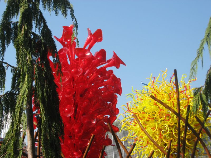
WOW. The Chihuly gardens and glass display was fantastic.

Chihuly Glass Mike and I hit the casino for a while this afternoon. Jim and Mary are visiting Jim’s son and family and meeting a brand new granddaughter. Tomorrow is get ready for Saturday’s cruise. Our radios and GPS’s have been invaluable when driving around a large city like Seattle where we get separated in the heavy traffic
PLEASE NOTE
This will be the last blog until after we get back from the cruise which is September 22nd.  We will let you know via email when we are on our journey again.  Thanks for joining us in on our travels and we look forward to hearing from you again.
Information on the Seattle Space Needle
compiled by maf
The story started on a napkin.....
In 1959, an unlikely artist  was sketching his vision of a dominant central structure for the 1962 Seattle World's Fair on a place mat in a coffee house.  The artist was Edward E. Carlson.  His  image was to be the focus of the futuristic World's Fair in Seattle, Carlson penciled the shape that would become the internationally known symbol for Seattle, the Space Needle.

However, Carlson soon found moving the symbol from the place mat to the drawing board was not an easy process.  Carlson's initial sketch underwent many transformations. One drawing resembled a tethered balloon and another was a balloon-shaped top house on a central column anchored by cables. Architect John Graham, fresh from his success in designing the world's first shopping mall (Seattle's Northgate), turned the balloon design into a flying saucer. A dozen architects on Graham's team worked on sketches and ideas before a final compromise was reached just a year and a half before the fair was to open.

The next hurdles were location and financing. Since the Space Needle was to be privately financed, it had to be situated on land which could be acquired for public use but built within the fairgrounds. Early investigations indicated such a plot of land did not exist. However, just before the search was abandoned, a suitable 120-foot-by-120-foot piece of land was found and sold to investors for $75,000 in 1961, just 13 months before the World's Fair opening.

Construction progressed quickly. An underground foundation was poured into a hole 30 feet deep and 120 feet across. It took 467 cement trucks an entire day to fill the hole, the largest continuous concrete pour ever attempted in the West. Once completed, the foundation weighed as much as the Space Needle itself, establishing the center of gravity just above ground.

The five level top house dome was completed with special attention paid to the revolving restaurant level and Observation Deck. The top house was balanced so perfectly that the restaurant rotated with just a one horsepower electric motor.  The final coats of paint were dubbed Astronaut White for the legs, Orbital Olive for the core, Re-entry Red for the halo and Galaxy Gold for the sunburst and pagoda roof. The 605-foot tall Space Needle was completed in December 1961 and officially opened a mere four months later on the first day of the World's Fair, April 21, 1962.

The Space Needle's elevators were the last pieces to arrive before the opening, the last one just one day before the fair opened. New, computerized elevators were installed in 1993. The elevators travel 10 mph, 14 feet per second, 800 feet per minute, or as fast as a raindrop falls to earth. In fact, a snowflake falls at 3 mph, so in an elevator during a snowstorm it appears to be snowing up.

Storms occasionally force closure of the Space Needle, as they did for the Columbus Day storm of 1962 and the "Inauguration Day" storm of 1993 when winds reached 90 miles per hour. The Needle is built to withstand a wind velocity of 200 miles per hour. The Space Needle has withstood several tremors, too, including a 2001 earthquake measuring 6.8 on the Richter scale. The tallest building west of the Mississippi River when it was built, the Space Needle has double the 1962 building code requirements, enabling the structure to withstand even greater jolts.

The Space Needle was built for just $4.5 million, and has had its share of milestones, including numerous weddings and a jump by six parachutists. During the World's Fair, nearly 20,000 people a day traveled to the top. The Space Needle hosted over 2.3 million visitors during the Fair and is still, over 40 years later, Seattle's number one tourist destination.

The history of Pike Place Market
Here is a snapshot of how the Market came to be. Between 1906 and 1907, the cost of onions increased tenfold. Outraged citizens, fed up with paying price-gouging middlemen too much for their produce, found a hero in Seattle City Councilman Thomas Revelle. Revelle proposed a public street market that would connect farmers directly with consumers. Customers would "Meet the Producer" directly, a philosophy that is still the foundation of all Pike Place Market businesses.
On August 17, 1907, Pike Place Market was born. On that first day, a total of eight farmers brought their wagons to the corner of First Avenue and Pike Street—and were quickly overwhelmed by an estimated 10,000 eager shoppers. By 11:00 am, they were sold out. Thousands of would-be customers went home empty-handed, but the chaos held promise. By the end of 1907, the first Market building opened, with every space filled.
A century later, Pike Place Market is internationally recognized as America's premier farmers' market and is home to more than 200 year-round commercial businesses; 190 craftspeople and approximately 100 farmers who rent table space by the day; 240 street performers and musicians; and more than 300 apartment units, most of which provide housing for low-income elderly people. "The Market," as the locals affectionately say, attracts 10 million visitors a year, making it one of Washington state's most frequently visited destinations.